Trip Report
 I was going on a trip to see family and friends on the east coast. My
mother had recently moved to the Eastern Shore (Neavitt, MD) and from
a previous trip it looked like an ideal place for cycling. I needed a
way to get from her house up to the Philadelphia area to take the
train to other portions of my trip.
I was going on a trip to see family and friends on the east coast. My
mother had recently moved to the Eastern Shore (Neavitt, MD) and from
a previous trip it looked like an ideal place for cycling. I needed a
way to get from her house up to the Philadelphia area to take the
train to other portions of my trip.
I asked on the touring list about routes in this area and got back
some very useful information from Larry O'Loane who sent me detailed
maps and a suggested route from Neavitt, MD to Wilmington, DE. The
route was just over 100 miles, which I figured would take two days and
fit well into my schedule of leaving on Monday and getting a train
to New York City on Wednesday morning.
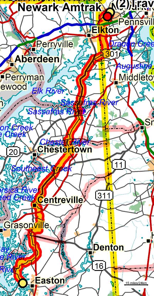
In looking a bit more at my route options and train routes I decided to cut the route short and take the train on Tuesday in the early afternoon from Newark, DE. I also started in St Michaels instead of Neavitt. I did go and ride some of that route on Sunday before leaving for my trip to make up for cutting it. My revised plan had me riding about 75 miles to Chesapeake City on the first day, and a short 20 mile ride to Newark to catch the 2:30 train on the second day.
 On Monday morning at about 8am my mother dropped me off a little bit
past St Michaels. The weather was wonderful, with a slight breeze
blowing towards the north, clear skies, and a temperature of about 70
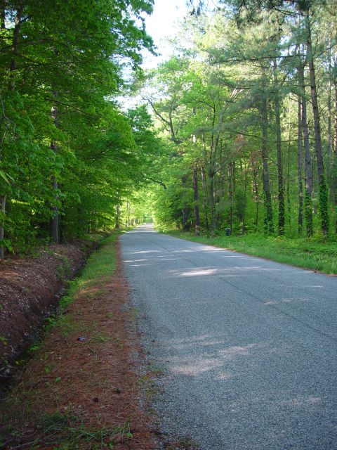
degrees. I started riding north towards Wye Mills and found that with
the flat roads and slight tailwind that I was easily maintaining a
20mph pace. The first few roads that I rode on had no shoulders, but
also had no traffic. Often there was full tree cover. I had to cross
50 twice and rode along it for about half a mile, but getting across
50 wasn't as difficult as I feared. Wye Mills came and went quickly and
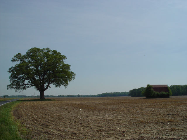
Centerville and Church Hills soon followed. Between Centerville and
Church Hills I was riding along SR213. It had more traffic than the
smaller roads that I started along, but it also had wide and very
clean shoulders. A few miles outside of Church Hills I stopped, ate
some food, and give my wife a quick call. At this point it was only
10:30a and I had already covered half of my planned miles for the day.
I began to wonder how the rest of the day would progress.
On Monday morning at about 8am my mother dropped me off a little bit
past St Michaels. The weather was wonderful, with a slight breeze
blowing towards the north, clear skies, and a temperature of about 70
degrees. I started riding north towards Wye Mills and found that with
the flat roads and slight tailwind that I was easily maintaining a
20mph pace. The first few roads that I rode on had no shoulders, but
also had no traffic. Often there was full tree cover. I had to cross
50 twice and rode along it for about half a mile, but getting across
50 wasn't as difficult as I feared. Wye Mills came and went quickly and
Centerville and Church Hills soon followed. Between Centerville and
Church Hills I was riding along SR213. It had more traffic than the
smaller roads that I started along, but it also had wide and very
clean shoulders. A few miles outside of Church Hills I stopped, ate
some food, and give my wife a quick call. At this point it was only
10:30a and I had already covered half of my planned miles for the day.
I began to wonder how the rest of the day would progress.
 15 miles (and less than an hour later) I stopped at a county park
and ate my lunch. At this point I noticed that I was running low on
water, and thought that I should find some pretzels to replenish some
of the salts that I had been sweating out. Stupidly I cycled right by
a gas station in Chesterville because it didn't look like they sold
snack foods, and I didn't find another one until Galena (about 5 miles
after draining my Camelbak). They didn't sell pretzels, but had
plenty of peanuts and I was able to refill my water supply. On the
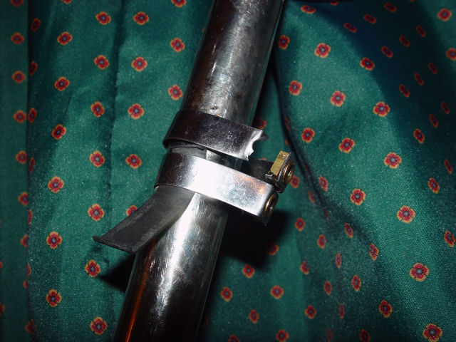
way out of the parking lot I heard a cracking noise and upon closer
inspection found that the bracket for my Carradice SQR had broken. I
secured my bag with a compression strap and kept going.
15 miles (and less than an hour later) I stopped at a county park
and ate my lunch. At this point I noticed that I was running low on
water, and thought that I should find some pretzels to replenish some
of the salts that I had been sweating out. Stupidly I cycled right by
a gas station in Chesterville because it didn't look like they sold
snack foods, and I didn't find another one until Galena (about 5 miles
after draining my Camelbak). They didn't sell pretzels, but had
plenty of peanuts and I was able to refill my water supply. On the
way out of the parking lot I heard a cracking noise and upon closer
inspection found that the bracket for my Carradice SQR had broken. I
secured my bag with a compression strap and kept going.
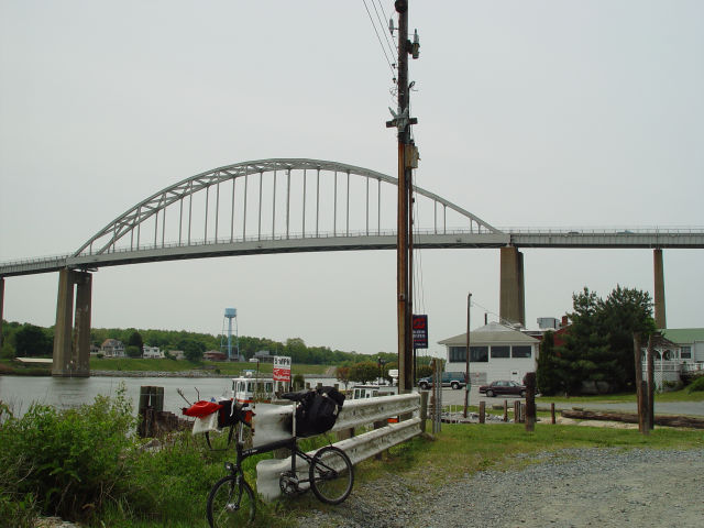 A little after noon I was on SR213 a few miles south of Chesapeake
City. I decided to keep going because I didn't know how I'd spend
half a day there and figured that the motels in Newark would be
cheaper than the B&Bs in Chesapeake City. I had to decide how to
cross the Chesapeake and Delaware Canal. I had been warned that the
SR213 bridge wasn't very good, but that the US301 was pretty bad too.
Since I was on SR213 I decided to give that one a try. It had a small
sidewalk on the northbound side and rode over on it. The skinny
sidewalk wouldn't have been much fun in bad weather, but in the light
breeze it was fine. The bridge looked daunting (and was the first
hill of the day), but it only took a few minutes to cross. I had
read that the police sometimes stop cyclists and make them walk across
the bridge, but no one stopped me.
A little after noon I was on SR213 a few miles south of Chesapeake
City. I decided to keep going because I didn't know how I'd spend
half a day there and figured that the motels in Newark would be
cheaper than the B&Bs in Chesapeake City. I had to decide how to
cross the Chesapeake and Delaware Canal. I had been warned that the
SR213 bridge wasn't very good, but that the US301 was pretty bad too.
Since I was on SR213 I decided to give that one a try. It had a small
sidewalk on the northbound side and rode over on it. The skinny
sidewalk wouldn't have been much fun in bad weather, but in the light
breeze it was fine. The bridge looked daunting (and was the first
hill of the day), but it only took a few minutes to cross. I had
read that the police sometimes stop cyclists and make them walk across
the bridge, but no one stopped me.
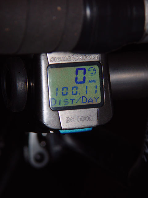 Past Chesapeake City the riding into Newark was easy although
traffic started to pick up. I went in circles around Newark before
finding a motel to stay at. I noticed that my odometer said 92 miles
and felt like I should really ride the extra 8 to make it a real
century (my first one!), but felt like showering and eating instead.
After a shower, some R&R, and a big burrito I did a lap around Newark
to complete the century. I celebrated with a Guinness.
Past Chesapeake City the riding into Newark was easy although
traffic started to pick up. I went in circles around Newark before
finding a motel to stay at. I noticed that my odometer said 92 miles
and felt like I should really ride the extra 8 to make it a real
century (my first one!), but felt like showering and eating instead.
After a shower, some R&R, and a big burrito I did a lap around Newark
to complete the century. I celebrated with a Guinness.
The next morning I took a much earlier train to New York and arrived at my friends house about 6 hours ahead of schedule. The 8 mile ride from Penn Station to their house in Brooklyn probably had fifty times as many cars on it as the entire trip through MD and DE.
Equipment
I rode this trip on my Swift Folder. It is equipped with drop bars and a Sachs Super 7 hub (no derailleurs). I carried my camera, cell phone, and food in my Ortlieb handlebar bag. I clothes, my laptop, and toiletries in my Carradice Camper. A Dahon bicycle bag (for covering the bicycle while taking the train) was strapped to the top of the Carradice. I used a Camelbak for water (even though I don't like them) because the Swift Folder doesn't have water bottle mounts and there aren't great places to put them.
Directions
These directions include getting lost in Newark trying to find a motel, but don't include my short ride to complete the century.
| Dist | Turn | Road |
| Start at | SR 370 | |
| Go straight(E) on | SR 33 (Easton Claiborne Rd) | |
| in 0.03 mi | Turn left(N) on to | SR 370 (Unionville Rd) |
| in 2.90 mi | Turn right(W) on to | SR 33 (Easton Claiborne Rd) |
| in 0.03 mi | Stop at | Alternate Start |
| Go straight(E) on | SR 33 (Easton Claiborne Rd) | |
| in 0.03 mi | Turn left(NW) on to | SR 370 (Unionville Rd) |
| in 1.55 mi | Go straight(NNW) on to | Unionville Rd |
| in 2.24 mi | Turn right(NNE) on to | Todds Corner Rd |
| in 2.04 mi | Turn right(ENE) on to | Presquile Rd |
| in 0.16 mi | Go straight(E) on to | Sharp Rd S |
| in 1.70 mi | Turn left(ENE) on to | Forest Landing Rd |
| in 1.31 mi | Turn left(N) on to | SR 662 (Longwoods Rd) |
| in 6.96 mi | Bear right(NNW) on to | SR 404 (Old Wye Mills Rd) |
| in 0.16 mi | Turn right(N) on to | SR 213 (Wye Mills Rd) |
| in 0.92 mi | Turn right(E) on to | Grange Hall Rd |
| in 1.77 mi | Turn left(N) on to | Poplar School Rd |
| in 2.61 mi | Turn left(WNW) on to | SR 309 (Starr Rd) |
| in 0.41 mi | Turn right(N) on to | Rolling Bridge Rd |
| in 2.88 mi | Turn left(NW) on to | SR 304 (Centreville Ruthsburg Rd) |
| in 1.26 mi | Turn right(NNE) on to | SR 213 (N Liberty St) |
| in 8.05 mi | Bear right(NE) on to | SR 19 (Main St) |
| in 1.10 mi | Bear right(NNE) on to | Pinder Hill Rd |
| in 1.39 mi | Bear right(NE) on to | Pondtown Rd |
| in 4.50 mi | Turn left(NNE) on to | SR 290 (Dudley Cors Rd) |
| in 10.27 mi | Go straight(NNE) on to | SR 213 (N Main St) |
| in 14.83 mi | Turn right(ENE) on to | SR 285 (Biddle St) |
| in 1.98 mi | Bear right(ENE) on to | Chesapeake City Rd MD/DE State Border |
| in 1.34 mi | Turn left(NNW) on to | Frazer Rd |
| in 1.11 mi | Bear right(N) on to | Denny Rd |
| in 0.02 mi | Bear left(NNW) on to | Local Road |
| in 0.03 mi | Bear right(N) on to | frazer |
| in 0.06 mi | Go straight(NNW) on to | Frazer Rd |
| in 3.07 mi | Turn right(E) on to | US 40 (Pulaski Hwy|Road 32) |
| in 0.28 mi | Turn left(N) on to | Pleasant Valley Rd |
| in 1.47 mi | Go straight(NNW) on to | Otts Chapel Rd |
| in 1.44 mi | Turn right(ENE) on to | W Chestnut Hill Rd |
| in 1.67 mi | Turn left(N) on to | SR 896 (S College Ave|Road 387) |
| in 0.14 mi | Bear right(N) on to | SR 2 (SR 4|SR 896|S College Ave) |
| in 0.09 mi | Turn left(WNW) on to | Christiana Pkwy (SR 2|SR 4|SR 896|Road 366) |
| in 1.45 mi | Turn right(NE) on to | SR 2 Bus (SR 896|Elkton Rd|Road 11) |
| in 0.77 mi | Turn right(E) on to | W Park Pl |
| in 0.65 mi | Bear left(E) on to | E Park Pl |
| in 0.56 mi | Turn left(NNW) on to | S Chapel St |
| in 0.53 mi | Turn right(ESE) on to | SR 2 Bus (E Delaware Ave) |
| in 0.22 mi | Turn left(N) on to | Tyre Ave |
| in 0.20 mi | Turn left(W) on to | SR 2 Bus (SR 273|E Main St) |
| in 0.02 mi | Stop at | Travelodge |
| Go straight(W) on | SR 2 Bus (SR 273|E Main St) | |
| in 0.60 mi | Turn left(S) on to | S College Ave (Road 387) |
| in 0.80 mi | Bear right(S) on to | Local Road |
| in 0.09 mi | Finish at | Newark Amtrak |