I purchased this atlas for a bicycle trip on the logging roads around the Lake Cowichan area. There are no other published maps of these roads that I'm aware of.
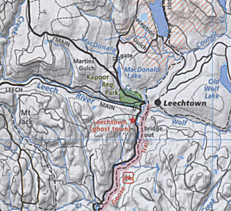
We approached the logging roads via the Galloping Goose trail near Leechtown and quickly learned that the map is very wrong. All of the points of interest are incorrectly mapped in this area. There are two markers for Leechtown, but neither points to the actual location of Leechtown. The location of Kapoor Regional Park is also incorrect (it is on the east side of the Sooke River, not the west side). And the vital part is that many of the logging roads shown on the map no longer seem to exist. We followed Leech Main (heading West) and found that it was completely washed out (we walked along it for a few hundred feet and couldn't find the other side) or may never have existed. The map was published in 2005, but the trees on the washout where 10' tall, so the washout was already fairly old.
While riding on the logging roads we talked to a few other locals and all reported that this atlas had many other similar mistakes and could not be trusted for navigating the logging roads. I realize that logging roads change, but this book appears to contain much older data than the publishing date would have you believe.
The text section in the first half of the book listing fishing spots, trails, and other points of interest is fairly unique among road atlases. It is inconsistent (for instance the atlas shows the Transcanada Trail on many pages but there is nothing about this in the text of the book) but sometimes helpful. It would be nice if this was published as a second book so that the maps could be carried seperately.
For paved road travel this book is okay. The maps are normally easy to read but notes and points of interest markers can be difficult to read or incorrectly located. For dirt and logging road travel it should be avoided. For paved road travel I think most users could get away with a less detailed map.
I wrote the review above to be published on Amazon so that it could easily be found. Amazon doesn't let me post photos, so I'm adding this drawing of the map to show some of the areas of confusion:
Here is a list of issues just in this tiny (about 5cm by 5cm) portion of the map:
A 150,000:1 scale map like this should be fairly accurate and useful for navigation. This map is not accurate and can't be trusted for navigation. In the front of the atlas they have a disclaimer stating that the maps are not accurate, and you should believer it. They also ask readers to send in GPS coordinates for points of interest, and I expect that these user submitted GPS coordinates are making the map less accurate, not more accurate. Backroad Mapbooks needs to redraw the maps, at least around the logging roads, if they want this book to be accurate enough for navigation.